Scenic USA - Texas
Each day Scenic USA presents a different and interesting photo feature from somewhere in
the United States. Chosen from a wide variety of historic sites, city scenes, back-country
byways, points of interest and America's best parklands, this site offers the viewer hundreds
of unique vacation destinations and photographic subjects. Each feature is coupled with a
brief explanation. For further detailed information, links to other sites are provided, however
these links should not be considered an endorsement.

Other nearby
Points of Interest
At no extra cost, using this link helps support Scenic USA when you shop on-line at Amazon
Colorado River - Texas
| Photos by Jason Merlo Jason Merlo Photography |
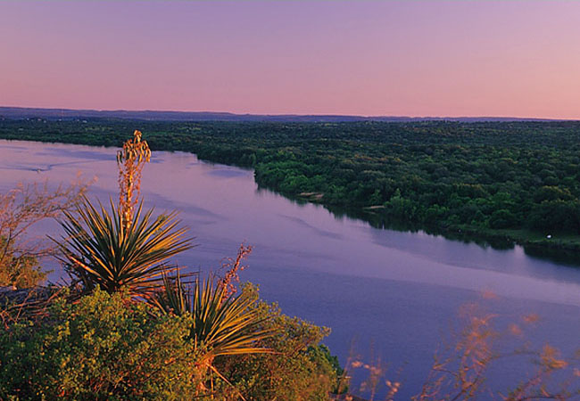
Easily confused in name with the great Colorado River of the Southwest, the Colorado River of Texas is the longest river within the state's borders. The 600 mile Colorado River is an important Texas resource, providing a source of water for farm irrigation, city water supplies, and hydro-electric power.
This evening view of the Colorado River, with its soft, subtle hues, makes a convincing statement about the river as scenic treasure. Offering a look at its recreational value, sightseers, photographers, boaters, paddlers and anglers find beauty along its riverbanks all across the state. Originating on the Llano Estacado in the western edges of the panhandle near Lubbock, the Colorado generally flows in a southeast direction through the rolling prairie of the West Texas high plains. As it winds its way southward through Texas Hill Country above Austin on the San Saba County line, it creates a section of gorgeous canyonlands. The section around Colorado Bend State Park is a popular recreation area for paddlers.  With many interesting side creeks and plentiful wildlife, this area of the river and surrounding land attracts many Texas visitors. One of the highlights of Colorado Bend State Park, among its high limestone bluffs, is Gorman Falls. Gorman Creek flows from mineral springs above, creating a beautiful 75 foot waterfall and a clear, cold pool below. Downstream, when not controlled by dams and reservoirs, the Colorado River is wide and relatively shallow. Flowing over riverbeds of limestone, sand and gravel, river paddlers find that a number of riverside sandbars make convenient overnight camping areas.
In the Austin area the Colorado is slowed by a string of manmade lakes known as the Highland Lakes. These reservoirs on the river include Lake Buchanan, Inks Lake, Lake LBJ, Lake Austin, and Lady Bird Lake.
Beyond the Austin area, the river approaches the lower Hill Country and lazily flows through the coastal lowlands. After traveling through a large swath of Texas, the Colorado empties into the Gulf of Mexico at Matagorda Bay.
Area Map
Copyright © 2011-14 Benjamin Prepelka
All Rights Reserved