Scenic USA - Maryland
Each day Scenic USA presents a different and interesting photo feature from somewhere in
the United States. Chosen from a wide variety of historic sites, city scenes, backcountry
byways, points of interest and America's best parklands, this site offers the viewer hundreds
of unique vacation destinations and photographic subjects. Each feature is coupled with a
brief explanation. For further detailed information, links to other sites are provided, however
these links should not be considered an endorsement.

Other nearby
Points of Interest
Eden Mill Nature Center and Park
At no extra cost to you, using this link helps support Scenic USA when you shop on-line at Amazon
Rocks State Park
| Photos by Ben Prepelka Ben's Panoramio Gallery |
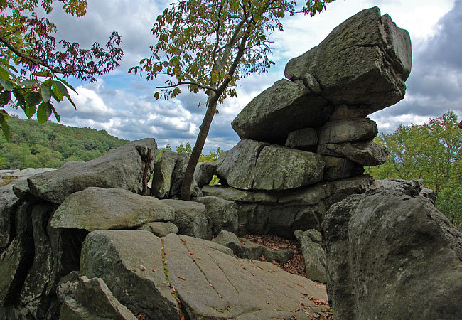
Soaring rock outcroppings, a beautiful waterfall, and the inviting Deer Creek create one of Maryland’s most interesting state parks. Believed to be a ceremonial gathering place for the Susquehannock Indian Tribe, the King and Queen Seat rock formations top off this craggy cliff face. The cliff top here provides a broad viewpoint of the Deer Creek Valley below.
Found just a few miles north of Forest Hill on Route 24, this Maryland state park is one of the scenic stops on the Deer Creek Loop, a section of the Mason Dixon Scenic Byway. Broken into separate parkland areas, the main section of Rocks State Park features three picnic areas. Playgrounds, pavilions, picnic tables and restrooms are provided at each of the day-use picnic sites. Here in the Rock Ridge Picnic Area, a short trail leads down to the King and Queen Seats, pictured here.  A very steep, informal pathway leads down along the cliff base where rock climbers can get a good look at Breakaway Wall, Blister, Epitaph and the Pinnacle, all offering some moderately challenging climbs. Climbers are warned about the dangers of climbs, and slippery mosses that grow on rock surfaces provide even more problems.
North of the main section of the park, Kilgore Falls is the centerpiece for the Falling Branch Area. This undeveloped section of the park, totaling 67 acres, surrounds Falling Branch, a tributary of Deer Creek. A hiking trail begins at the Falling Branch Road parking lot and leads out to the waterfall. Stepping stones are strategically placed across Fall Branch Creek, but there’s always a chance you’ll get your feet wet on this waterfall hike. Kilgore Falls is the second highest falls in the state and well worth the short hike.
Area Map
Copyright © 2011-14 Benjamin Prepelka
All Rights Reserved