Scenic USA - Nebraska
Each day Scenic USA presents a different and interesting photo feature from somewhere in
the United States of America. Chosen from a wide variety of historic sites, city scenes, back-
country
byways, points of interest and America's popular parklands, this site offers the viewer
hundreds of unique vacation destinations and photographic subjects. Each photo is coupled
with a brief explanation. For further detailed information, web links to other sites are provided,
however these links should not be considered any type of endorsement.

Scenic Byway
Points of Interest
Agate Fossil Beds National Monument
Arthur Bowring Sandhills Ranch SHP
At no extra cost to you, using this link helps support Scenic USA when you shop on-line at Amazon
Bridges to Buttes Byway
| Photos by Ben Prepelka |
Heading west from Valentine, Nebraska's Bridges to Buttes Byway follows U.S. Route 20 for nearly 200 miles. Tracing the  Niobrara River Valley, through the Sandhills and Pine Ridge topography of the northwest corner of the state, to the Buttes of Old West fame, the byway journey offers a look at an incredibly diverse section of the country.
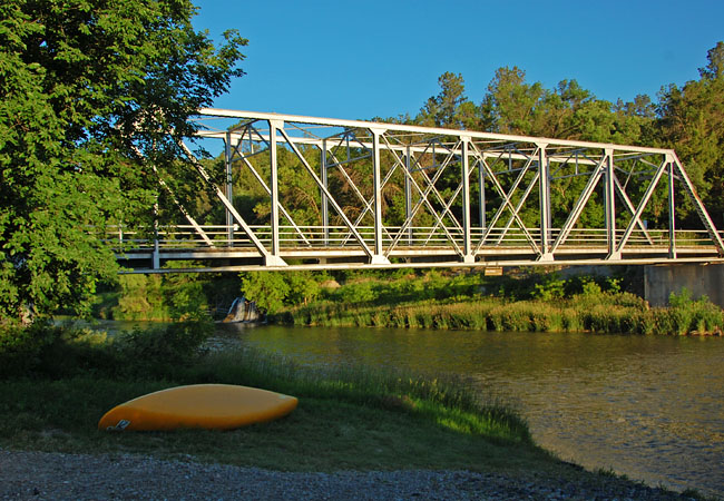
Fifteen bridges span Niobrara River and two just upstream make up the bridges section of the byway. Of the 17 bridges, five have been placed on the National Register of Historic Places. This view shows the Berry Bridge, completed in 1921. Built by the Pioneer Construction Company, the bridge remains basically unaltered during the last 90 years. The small Berry Falls, seen under the bridge, lends its name to the bridge and nearby river outfitters.
A 19,000 square mile area of  grass covered dunes, called the Nebraska Sandhills, is one of the most unique areas in the world. Resting over the Ogallala Aquifer, the Sandhills region is the largest dune area in the western hemisphere. Following the last ice age, strong winds stacked an incredible amount of sand over 400 feet deep. Carefully managed by ranchers today, keeping the Sandhills covered in vegetation is of the upmost importance.
The byway ends near the town of Harrison, an area of the highest elevation in the entire state.  Here the pine studded buttes and dramatic rock formations of the Toadstool Geological Park represent the buttes section of the byway. This is cowboy country, where authentic cowpokes still work the vast stretches of prairie, broken only by northwest Nebraska’s distinctive ridges and buttes.
Bridges to Buttes Byway Map
Copyright © 2013-15 Benjamin Prepelka
All Rights Reserved