Scenic USA - North Carolina

Each day Scenic USA presents a new and interesting photo feature from somewhere in the United States. Chosen from a wide variety
of historic sites, city scenes, backcountry byways, points of interest and America's best parklands, this site offers the viewer hundreds
of unique vacation destinations and photographic subjects. Each feature is coupled with a brief explanation. For further detailed
information, links to other sites are provided, but are never to be considered an endorsement.

Previous
Archives
Home
Next


Scenic USA on Facebook

Scenic USA on Facebook


Other nearby
Points of Interest

Nags Head

Kitty Hawk

Wright Brothers Memorial

Cape Hatteras National Seashore

Jockey Ridge State Park

Roanoke Island

Fort Raleigh NHS

Hatteras Lighthouse


Use this link to help
support Scenic USA when you shop Amazon


Pea Island

Photos by Ben Prepelka

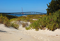
     During an Atlantic hurricane in 1848, the fierce storm swept across the Outer Banks at Bodie Island separating it in two. The Oregon rode out the storm in Pamlico Sound and was first to report the new inlet. A ferry service was set up to bridge the gap to the Pea Island, handling peak traffic of 2000 people a day. Long lines and the ferry's high cost prompted state officials to seek funds for a bridge. The Herbert C. Bonner Bridge, spanning the two and a half mile gap, was completed in 1963. Herbert C. Bonner Bridge - Oregon Inlet, Outer Banks, NC
     With the completion of the Oregon Inlet Bridge, visitors flocked to the Pea Island Wildlife Refuge, known today as a birder's paradise. A haven for over 365 bird species, the 6000 acre refuge provides 1000 acres of waterfowl impoundments and two year-round wildlife trails maintained by Friends of Pea Island NWR. Established in 1937, the refuge also provides 13 miles of solitary beach, a pristine habitat for piping plovers, loggerhead turtles, bald eagles and peregrine falcons. The refuge is a popular stop along the long string of Outer Banks barrier islands.
     When the Bonner Bridge was designed, little did anyone realize the nature of the shifting sands in the inlet. Moving about 65 feet every year, the cut has moved over two miles since it was first created. Heading the list of unsafe bridges in the state, the Oregon Inlet Bridge is on the plate for replacement. Scheduled to be completed in 2015, the old Bonner Bridge is destined to be a fishing pier.

    Refuge Map
    Area Map


    Copyright © 2013 Benjamin Prepelka
    All Rights Reserved